Geolocate

Deventer topographic map

Click on the map to display elevation.

About this map

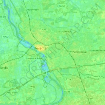
Name: Deventer topographic map, elevation, terrain.

Location: Deventer, Overijssel, Netherlands (52.21744 6.12111 52.28111 6.27592)

Average elevation: 7 m

Minimum elevation: -4 m

Maximum elevation: 19 m

Other topographic maps

Click on a map to view its topography, its elevation and its terrain.

Witteberg

Netherlands > Overijssel

Average elevation: 57 m

Zuurberg

Netherlands > Overijssel > Holten

Average elevation: 17 m

Tankenberg

Netherlands > Overijssel > de Lutte

Average elevation: 58 m

Helhuizen

Netherlands > Overijssel > Holten

Average elevation: 20 m

Usselo

Netherlands > Overijssel > Enschede

Average elevation: 31 m

Frankhuis

Netherlands > Overijssel > Zwolle

Average elevation: 3 m

Enschede

Netherlands > Overijssel > Enschede

Average elevation: 34 m

Gear up for your next adventure:

👟Women's Trail Running Shoes - Agile footwear for fell running and technical trails
🧘Folding Sit Mats - Dry and warm seat for map-reading breaks on damp ground
👟Heavy Duty Boot Laces - Always carry a spare for your hiking footwear
🗺️Ordnance Survey Maps - Official UK maps for walking and outdoor activities
🧥Breathable Waterproof Jackets - Essential rain protection for the unpredictable British climate

As an Amazon Associate, this site earns from qualifying purchases at no extra cost to you.