Geolocate

Divis topographic map

Click on the map to display elevation.

About this map

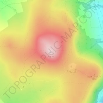
Name: Divis topographic map, elevation, terrain.

Location: Divis, Belfast, County Antrim, Northern Ireland, BT17 0NG, United Kingdom (54.61123 -6.01852 54.61133 -6.01842)

Average elevation: 330 m

Minimum elevation: 145 m

Maximum elevation: 476 m

County Antrim trails, hiking, mountain biking, running and outdoor activities

Other topographic maps

Click on a map to view its topography, its elevation and its terrain.

Gear up for your next adventure:

🛌Sleeping Bags - Warm and packable sleeping bags for outdoor nights
👟Heavy Duty Boot Laces - Always carry a spare for your hiking footwear
🌄Compact Monoculars - Lightweight optics for hiking
🔦Waterproof LED Headlamps - Hands-free lighting for evening treks and emergency navigation
🔭Compact Hiking Binoculars - Lightweight optics for scouting terrain and spotting wildlife

As an Amazon Associate, this site earns from qualifying purchases at no extra cost to you.