
Rott topographic map
Interactive map
Click on the map to display elevation.
About this map
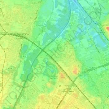
Name: Rott topographic map, elevation, terrain.
Location: Rott, Salzburg, 5020, Österreich (47.81022 12.97551 47.85022 13.01551)
Average elevation: 419 m
Minimum elevation: 399 m
Maximum elevation: 441 m
Other topographic maps
Click on a map to view its topography, its elevation and its terrain.
Gaisberg
Österreich > Salzburg > Salzburg
Gaisberg, Salzburg, 5020, Österreich
Average elevation: 727 m
Langwied
Österreich > Salzburg > Salzburg
Langwied, Salzburg, 5020, Österreich
Average elevation: 484 m
Festung Hohensalzburg
Österreich > Salzburg > Salzburg
Festung Hohensalzburg, 34, Mönchsberg, Altstadt, Salzburg, 5020, Österreich
Average elevation: 440 m
Mönchsberg
Österreich > Salzburg > Salzburg
Mönchsberg, Mönchsbergstiege, Riedenburg, Salzburg, 5020, Österreich
Average elevation: 436 m