
Make a donation
Gear up for your next adventure:
As an Amazon Associate, this site earns from qualifying purchases at no extra cost to you.
San Pedro del Pinatar topographic map
Click on the map to display elevation.
Make a donation
Gear up for your next adventure:
As an Amazon Associate, this site earns from qualifying purchases at no extra cost to you.
About this map
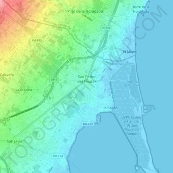
Name: San Pedro del Pinatar topographic map, elevation, terrain.
Average elevation: 17 m
Minimum elevation: -7 m
Maximum elevation: 95 m
Make a donation
Gear up for your next adventure:
As an Amazon Associate, this site earns from qualifying purchases at no extra cost to you.
Other topographic maps
Click on a map to view its topography, its elevation and its terrain.
Hacienda del Álamo
Spain > Region of Murcia > Campo de Cartagena y Mar Menor > Fuente Álamo de Murcia
Average elevation: 185 m
Cabezo de la Plata
Spain > Region of Murcia > Campo de Cartagena y Mar Menor > Cartagena
Average elevation: 85 m
Monte Sacro
Spain > Region of Murcia > Campo de Cartagena y Mar Menor > Cartagena
Average elevation: 12 m