
Hochspeyer topographic map
Interactive map
Click on the map to display elevation.
About this map
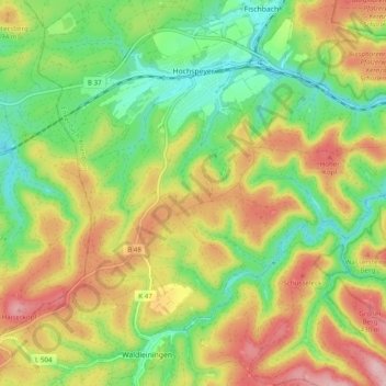
Name: Hochspeyer topographic map, elevation, terrain.
Average elevation: 344 m
Minimum elevation: 256 m
Maximum elevation: 457 m
Hochspeyer liegt auf einer Höhe von etwa 270 m ü. NHN am nördlichen Rand des Pfälzerwalds im Biosphärenreservat Pfälzerwald-Vosges du Nord. Nachbargemeinden sind – im Uhrzeigersinn – Fischbach, Frankenstein, Waldleiningen und Kaiserslautern.
Other topographic maps
Click on a map to view its topography, its elevation and its terrain.
Landstuhl
Deutschland > Rheinland-Pfalz > Landkreis Kaiserslautern > Landstuhl
Landstuhl, Landkreis Kaiserslautern, Rheinland-Pfalz, 66849, Deutschland
Average elevation: 329 m