
Zavodovski Island topographic map
Interactive map
Click on the map to display elevation.
Zavodovski Island
The island is one of the most active volcanoes in the South Sandwich Islands. It was reported to be smoking by von Bellingshausen, who observed emissions from the crater and noted a smell of sulfur, and there are frequent reports of steam emission. Reports of eruptions in 1823, 1830 and 1908 may refer to fumarolic activity. In 1830 fresh lava and floating pumices were reported from the eastern side, and a ship reported an eruption column in 1970. In March 2016, an eruption produced a volcanic cloud and ash and lava bombs fallout, covering pars of the island and leading the government of South Georgia to issue a navigation warning. Reported inconsistencies of the height of Mount Curry may indicate volcanic activity that changed the summit elevation of the volcano. Undamaged penguin bodies buried by volcanic ash have been found, and activity may have obliterated breeding seabird colonies.
About this map
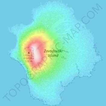
Name: Zavodovski Island topographic map, elevation, terrain.
Average elevation: 50 m
Minimum elevation: -1 m
Maximum elevation: 491 m
Other topographic maps
Click on a map to view its topography, its elevation and its terrain.
Cook Island
South Georgia and the South Sandwich Islands > South Sandwich Islands
Average elevation: 193 m
Cook Island
South Georgia and the South Sandwich Islands > South Sandwich Islands
Average elevation: 201 m