
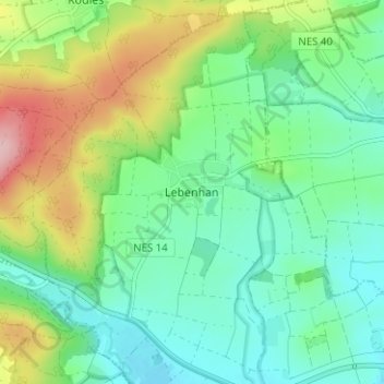
Lebenhan topographic map
Interactive map
Click on the map to display elevation.
About this map
Name: Lebenhan topographic map, elevation, terrain.
Average elevation: 308 m
Minimum elevation: 251 m
Maximum elevation: 435 m
Other topographic maps
Click on a map to view its topography, its elevation and its terrain.
Bad Neustadt an der Saale
Deutschland > Bayern > Landkreis Rhön-Grabfeld > Bad Neustadt an der Saale
Bad Neustadt an der Saale, Landkreis Rhön-Grabfeld, Bayern, 97616, Deutschland
Average elevation: 286 m
Schweinhof
Deutschland > Bayern > Landkreis Rhön-Grabfeld > Bad Neustadt an der Saale > Lebenhan
Schweinhof, Lebenhan, Bad Neustadt an der Saale, Landkreis Rhön-Grabfeld, Bayern, 97618, Deutschland
Average elevation: 304 m