
Marsh Cove topographic map
Interactive map
Click on the map to display elevation.
About this map
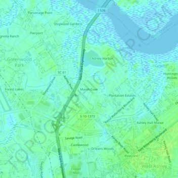
Name: Marsh Cove topographic map, elevation, terrain.
Average elevation: 4 m
Minimum elevation: -10 m
Maximum elevation: 11 m
Other topographic maps
Click on a map to view its topography, its elevation and its terrain.
Johns Island
United States > South Carolina > Charleston County > Charleston
Johns Island, Charleston, Charleston County, South Carolina, United States
Average elevation: 3 m
Woodlawn
United States > South Carolina > Charleston County > Charleston
Woodlawn, Charleston, Charleston County, South Carolina, 29422, United States
Average elevation: 3 m
Ashley Hall Manor
United States > South Carolina > Charleston County > Charleston
Ashley Hall Manor, Charleston, Charleston County, South Carolina, 29407, United States
Average elevation: 5 m
Hibernian Heights
United States > South Carolina > Charleston County > Charleston
Hibernian Heights, Charleston, Charleston County, South Carolina, 29409, United States
Average elevation: 3 m
Hickory Hall Plantation
United States > South Carolina > Charleston County > Charleston
Hickory Hall Plantation, Charleston, Charleston County, South Carolina, 29414, United States
Average elevation: 5 m
Stone Park
United States > South Carolina > Charleston County > Charleston
Stone Park, Charleston, Charleston County, South Carolina, 29407, United States
Average elevation: 4 m
Saint Andrews
United States > South Carolina > Charleston County > Charleston
Saint Andrews, Charleston, Charleston County, South Carolina, 29407, United States
Average elevation: 3 m
Grove Creek Village
United States > South Carolina > Charleston County > Charleston
Grove Creek Village, Charleston, Charleston County, South Carolina, 29407, United States
Average elevation: 3 m
Moreland
United States > South Carolina > Charleston County > Charleston
Moreland, Charleston, Charleston County, South Carolina, 29409, United States
Average elevation: 3 m
Rosemont
United States > South Carolina > Charleston County > Charleston
Rosemont, Charleston, Charleston County, South Carolina, 29409, United States
Average elevation: 4 m
Carolina Bay
United States > South Carolina > Charleston County > Charleston
Carolina Bay, Charleston, Charleston County, South Carolina, 29414, United States
Average elevation: 4 m
Ashley River
United States > South Carolina > Charleston County > Charleston
Ashley River, Charleston, Charleston County, South Carolina, 29425, United States
Average elevation: 3 m
Myrtle Grove
United States > South Carolina > Charleston County > Charleston > Myrtle Grove
Myrtle Grove, Charleston, Charleston County, South Carolina, 29414, United States
Average elevation: 4 m
Seaside
United States > South Carolina > Charleston County > Charleston > Seaside
Seaside, Charleston, Charleston County, South Carolina, 29412, United States
Average elevation: 2 m
Fenwick Crossroads
United States > South Carolina > Charleston County > Charleston > Fenwick Crossroads
Fenwick Crossroads, Charleston, Charleston County, South Carolina, 29457, United States
Average elevation: 5 m
Red Top
United States > South Carolina > Charleston County > Charleston
Red Top, Charleston, Charleston County, South Carolina, United States
Average elevation: 3 m
Maryville
United States > South Carolina > Charleston County > Charleston > Maryville
Maryville, Charleston, Charleston County, South Carolina, 29407, United States
Average elevation: 4 m
Oakcrest
United States > South Carolina > Charleston County > Charleston > Oakcrest
Oakcrest, Charleston, Charleston County, South Carolina, 29412, United States
Average elevation: 4 m
Wragg Borough Homes
United States > South Carolina > Charleston County > Charleston > Wragg Borough Homes
Wragg Borough Homes, Charleston, Charleston County, South Carolina, 29424, United States
Average elevation: 3 m
Gadsden Green Homes
United States > South Carolina > Charleston County > Charleston > Gadsden Green Homes
Gadsden Green Homes, Charleston, Charleston County, South Carolina, 29425, United States
Average elevation: 4 m