Geolocate

Town of Binghamton topographic map

Interactive map

Click on the map to display elevation.

About this map

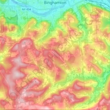
Name: Town of Binghamton topographic map, elevation, terrain.

Location: Town of Binghamton, Broome County, New York, 13903, United States (41.99843 -75.95993 42.10088 -75.85967)

Average elevation: 417 m

Minimum elevation: 247 m

Maximum elevation: 573 m

Other topographic maps

Click on a map to view its topography, its elevation and its terrain.

Tunnel

United States > New York > Broome County

Average elevation: 467 m

Edson

United States > New York > Broome County

Average elevation: 456 m

Hawleyton

United States > New York > Broome County

Average elevation: 456 m

Harpursville

United States > New York > Broome County

Average elevation: 351 m

Port Crane

United States > New York > Broome County

Average elevation: 346 m

West Windsor

United States > New York > Broome County

Average elevation: 457 m

Harpursville

United States > New York > Broome County

Average elevation: 351 m

Nineveh

United States > New York > Broome County

Average elevation: 338 m

Binghamton

United States > New York > Broome County > Binghamton

Average elevation: 397 m

Flowers

United States > New York > Broome County > Flowers

Average elevation: 484 m