
Villette topographic map
Interactive map
Click on the map to display elevation.
About this map
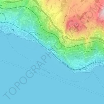
Name: Villette topographic map, elevation, terrain.
Average elevation: 472 m
Minimum elevation: 369 m
Maximum elevation: 880 m
Other topographic maps
Click on a map to view its topography, its elevation and its terrain.
Grandvaux
Suisse > Vaud > District de Lavaux-Oron > Bourg-en-Lavaux
Grandvaux, Bourg-en-Lavaux, District de Lavaux-Oron, Vaud, 1091, Suisse
Average elevation: 490 m