
Abuko topographic map
Interactive map
Click on the map to display elevation.
Abuko
Abuko is 15 metres (49 ft) above sea level. The surrounding land is mainly flat. The highest point nearby has an elevation of 26 metres (85 ft), 1 kilometre (0.62 mi) south of Abuko. The vegetation around Abuko is almost all fields. Peninsulas and islands are common in the region.
About this map
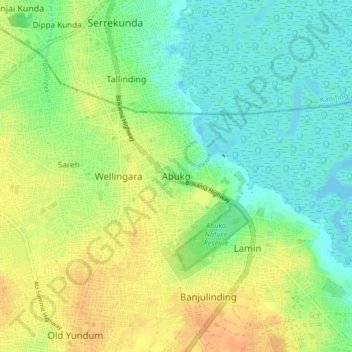
Name: Abuko topographic map, elevation, terrain.
Average elevation: 15 m
Minimum elevation: -1 m
Maximum elevation: 33 m
Other topographic maps
Click on a map to view its topography, its elevation and its terrain.
Salagi Forest Park
The Gambia > West Coast Division > Kombo North/Saint Mary > Labakoreh
Average elevation: 23 m
Bijilo Forest Park
The Gambia > West Coast Division > Kombo North/Saint Mary > Sukuta
Average elevation: 13 m