
Olesa de Montserrat topographic map
Interactive map
Click on the map to display elevation.
About this map
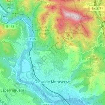
Name: Olesa de Montserrat topographic map, elevation, terrain.
Average elevation: 220 m
Minimum elevation: 64 m
Maximum elevation: 591 m
Other topographic maps
Click on a map to view its topography, its elevation and its terrain.
Platja de la Pineda de Viladecans
Spanje > Catalonië > Baix Llobregat > Viladecans
Platja de la Pineda de Viladecans, Viladecans, Baix Llobregat, Barcelona, Catalonië, 08840, Spanje
Average elevation: 2 m