
Thank you for supporting this site ❤️
Make a donation
Make a donation
Gear up for your next adventure:
As an Amazon Associate, this site earns from qualifying purchases at no extra cost to you.
Saluni topographic map
Click on the map to display elevation.
Thank you for supporting this site ❤️
Make a donation
Make a donation
Gear up for your next adventure:
As an Amazon Associate, this site earns from qualifying purchases at no extra cost to you.
About this map
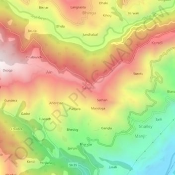
Name: Saluni topographic map, elevation, terrain.
Location: Saluni, Chamba District, Himachal Pradesh, 176320, India (32.70041 76.03221 32.74041 76.07221)
Average elevation: 1,389 m
Minimum elevation: 782 m
Maximum elevation: 1,956 m
Thank you for supporting this site ❤️
Make a donation
Make a donation
Gear up for your next adventure:
As an Amazon Associate, this site earns from qualifying purchases at no extra cost to you.