
Make a donation
Gear up for your next adventure:
As an Amazon Associate, this site earns from qualifying purchases at no extra cost to you.
Lac au Canard topographic map
Click on the map to display elevation.
Make a donation
Gear up for your next adventure:
As an Amazon Associate, this site earns from qualifying purchases at no extra cost to you.
About this map
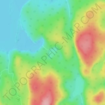
Name: Lac au Canard topographic map, elevation, terrain.
Average elevation: 297 m
Minimum elevation: 238 m
Maximum elevation: 386 m
Make a donation
Gear up for your next adventure:
As an Amazon Associate, this site earns from qualifying purchases at no extra cost to you.
Other topographic maps
Click on a map to view its topography, its elevation and its terrain.
Lac Mékinac
Canada > Québec > Mékinac > Trois-Rives
Une presqu'île située au milieu du lac Mékinac, sur la rive Est (dans la municipalité de Trois-Rives), est désignée le Trou-du-Steamboa, à la sortie du bras Groleau dont le sommet de la montagne voisine (côté nord) atteint plus de 320 mètres d'altitude. Dans ce secteur, les montagnes des deux côtés…
Average elevation: 287 m
Make a donation
Gear up for your next adventure:
As an Amazon Associate, this site earns from qualifying purchases at no extra cost to you.