Geolocate

Col Agnel / Colle dell'Agnello topographic map

Interactive map

Click on the map to display elevation.

About this map

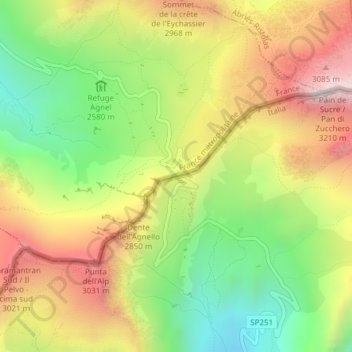
Name: Col Agnel / Colle dell'Agnello topographic map, elevation, terrain.

Location: Col Agnel / Colle dell'Agnello, Pontechianale, Cuneo, Piedmont, Italy (44.68387 6.97952 44.68397 6.97962)

Average elevation: 2,700 m

Minimum elevation: 2,279 m

Maximum elevation: 3,165 m

Other topographic maps

Click on a map to view its topography, its elevation and its terrain.

Monviso

Italy > Piedmont > Cuneo > Pontechianale

Monviso, Pontechianale, Cuneo, Piedmont, Italy

Average elevation: 2,985 m