
Make a donation
Gear up for your next adventure:
As an Amazon Associate, this site earns from qualifying purchases at no extra cost to you.
Irvine Lake topographic map
Click on the map to display elevation.
Make a donation
Gear up for your next adventure:
As an Amazon Associate, this site earns from qualifying purchases at no extra cost to you.
About this map
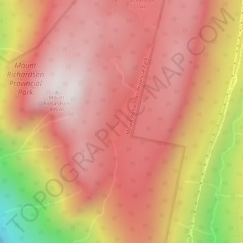
Name: Irvine Lake topographic map, elevation, terrain.
Average elevation: 673 m
Minimum elevation: 20 m
Maximum elevation: 978 m
Make a donation
Gear up for your next adventure:
As an Amazon Associate, this site earns from qualifying purchases at no extra cost to you.
Other topographic maps
Click on a map to view its topography, its elevation and its terrain.
Secret Cove
Canada > British Columbia > Sunshine Coast Regional District > Area B (Halfmoon Bay)
Average elevation: 88 m
Halfmoon Bay
Canada > British Columbia > Sunshine Coast Regional District > Area B (Halfmoon Bay)
Average elevation: 102 m
Halfmoon Bay
Canada > British Columbia > Sunshine Coast Regional District > Area B (Halfmoon Bay) > Halfmoon Bay
Average elevation: 16 m