
Lamas topographic map
Interactive map
Click on the map to display elevation.
About this map
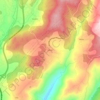
Name: Lamas topographic map, elevation, terrain.
Location: Lamas, Moledo, Castro Daire, Viseu, 3600-432, Portugal (40.81205 -7.93298 40.85205 -7.89298)
Average elevation: 534 m
Minimum elevation: 346 m
Maximum elevation: 671 m
Other topographic maps
Click on a map to view its topography, its elevation and its terrain.
Vila Meã
Portugal > Viseu > Castro Daire > Moledo
Vila Meã, Moledo, Castro Daire, Viseu, Portugal
Average elevation: 646 m