
Iitti topographic map
Interactive map
Click on the map to display elevation.
About this map
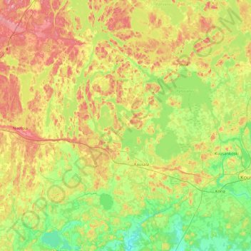
Name: Iitti topographic map, elevation, terrain.
Average elevation: 82 m
Minimum elevation: 30 m
Maximum elevation: 169 m
Other topographic maps
Click on a map to view its topography, its elevation and its terrain.
Lahti
Lahti, Lahden seutukunta, Päijät-Häme, Etelä-Suomen aluehallintovirasto, Manner-Suomi, Finlande
Average elevation: 105 m