
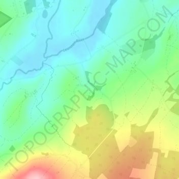
Ards Big topographic map
Interactive map
Click on the map to display elevation.
About this map
Name: Ards Big topographic map, elevation, terrain.
Average elevation: 62 m
Minimum elevation: 8 m
Maximum elevation: 166 m
Other topographic maps
Click on a map to view its topography, its elevation and its terrain.
Croaghross
Ireland > County Donegal > Letterkenny
Croaghross, Greenfort ED, Letterkenny, County Donegal, Ireland
Average elevation: 25 m
Rosapenna
Ireland > County Donegal > Letterkenny
Rosapenna, Rosguill ED, Letterkenny, County Donegal, Ireland
Average elevation: 11 m
Corkey
Ireland > County Donegal > Letterkenny
Corkey, Kincraigy ED, Letterkenny, County Donegal, Ireland
Average elevation: 36 m
Gortlee
Ireland > County Donegal > Letterkenny
Gortlee, Letterkenny Rural ED, Letterkenny, County Donegal, Ulster, Ireland
Average elevation: 34 m
Moyle
Ireland > County Donegal > Letterkenny
Moyle, Ballyarr ED, Letterkenny, County Donegal, Ireland
Average elevation: 55 m