Geolocate

Maroua topographic map

Click on the map to display elevation.

About this map
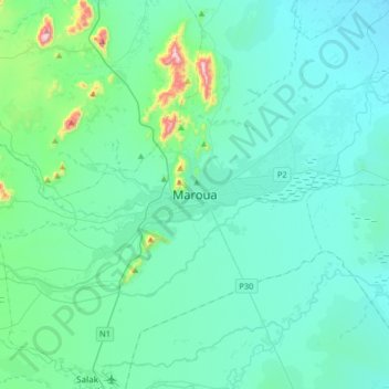
Name: Maroua topographic map, elevation, terrain.

Location: Maroua, Maroua II, Communauté urbaine de Maroua, Diamaré, Far-North, Cameroon (10.44331 14.16816 10.76331 14.48816)

Average elevation: 421 m

Minimum elevation: 349 m

Maximum elevation: 949 m

Other topographic maps

Click on a map to view its topography, its elevation and its terrain.

Dargala

Cameroon > Far-North > Diamaré

Average elevation: 352 m

Meri

Cameroon > Far-North > Diamaré

Average elevation: 574 m

Bogo

Cameroon > Far-North > Diamaré

Average elevation: 328 m

Gear up for your next adventure:

🔭Compact Hiking Binoculars - Lightweight optics for scouting terrain and spotting wildlife
🧤Hiking Gloves - Warm and durable gloves for cold-weather walks
🥾Women's Waterproof Hiking Boots - High-performance trekking boots designed for all-weather comfort
🐕Dog Hiking Gear - Equipment for hiking safely with dogs
🧦Merino Wool Hiking Socks - Moisture-wicking socks to prevent blisters during long mountain walks

As an Amazon Associate, this site earns from qualifying purchases at no extra cost to you.