
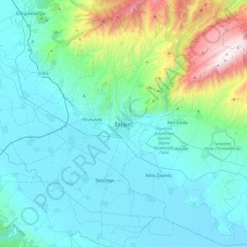
Serres topographic map
Interactive map
Click on the map to display elevation.
About this map
Name: Serres topographic map, elevation, terrain.
Average elevation: 317 m
Minimum elevation: -1 m
Maximum elevation: 1,951 m
Serres is one of the administrative and economic centers of Northern Greece. The city is situated in a fertile plain at an elevation of about 70 metres (230 feet), some 24 kilometres (15 miles) northeast of the Strymon river and 69 km (43 mi) north-east of Thessaloniki, respectively. Serres' official municipal population was 76,817 in 2011 with the total number of people living in the city and its immediate surroundings estimated at around 100,000.
Other topographic maps
Click on a map to view its topography, its elevation and its terrain.
Παλαιά Καστανούσα
Greece > Macedonia and Thrace > Serres Regional Unit
Παλαιά Καστανούσα, Sintiki Municipality, Serres Regional Unit, Central Macedonia, Macedonia and Thrace, Greece
Average elevation: 575 m
Νέο Πετρίτσι
Greece > Macedonia and Thrace > Serres Regional Unit
Νέο Πετρίτσι, Sintiki Municipality, Serres Regional Unit, Central Macedonia, Macedonia and Thrace, 620 43, Greece
Average elevation: 210 m
Promachonas
Greece > Macedonia and Thrace > Serres Regional Unit
Promachonas, Sintiki Municipality, Serres Regional Unit, Central Macedonia, Macedonia and Thrace, 623 00, Greece
Average elevation: 129 m
Καπνόφυτο
Greece > Macedonia and Thrace > Serres Regional Unit
Καπνόφυτο, Sintiki Municipality, Serres Regional Unit, Central Macedonia, Macedonia and Thrace, 623 00, Greece
Average elevation: 472 m
Angistro
Greece > Macedonia and Thrace > Serres Regional Unit > Angistro
Angistro, Sintiki Municipality, Serres Regional Unit, Central Macedonia, Macedonia and Thrace, 62300, Greece
Average elevation: 348 m
Nigrita
Greece > Macedonia and Thrace > Serres Regional Unit > Nigrita
Nigrita, Visaltia Municipality, Serres Regional Unit, Central Macedonia, Macedonia and Thrace, 62200, Greece
Average elevation: 117 m
Sidirokastro
Greece > Macedonia and Thrace > Serres Regional Unit
Sidirokastro, Sintiki Municipality, Serres Regional Unit, Central Macedonia, Macedonia and Thrace, 623 00, Greece
Average elevation: 155 m