Geolocate

Scharnitz topographic map

Click on the map to display elevation.

About this map

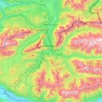
Name: Scharnitz topographic map, elevation, terrain.

Location: Scharnitz, Bezirk Innsbruck-Land, Tyrol, 6108, Austria (47.32657 11.20996 47.44992 11.52211)

Average elevation: 1,448 m

Minimum elevation: 603 m

Maximum elevation: 2,671 m

Other topographic maps

Click on a map to view its topography, its elevation and its terrain.

Nordkette

Austria > Tyrol > Bezirk Innsbruck-Land > Rum

Average elevation: 1,363 m

Medraz

Austria > Tyrol > Bezirk Innsbruck-Land > Fulpmes

Average elevation: 1,277 m

Gaistal

Austria > Tyrol > Bezirk Innsbruck-Land > Leutasch

Average elevation: 1,731 m

Gschnitztal

Austria > Tyrol > Bezirk Innsbruck-Land > Trins

Average elevation: 1,829 m

Klamm

Austria > Tyrol > Bezirk Innsbruck-Land > Leutasch

Average elevation: 1,366 m

Fotschertal

Austria > Tyrol > Bezirk Innsbruck-Land > Sellrain

Average elevation: 1,970 m

Kreuzjöchl

Austria > Tyrol > Bezirk Innsbruck-Land > Navis

Average elevation: 2,197 m

Hohe Munde Ostgipfel

Austria > Tyrol > Bezirk Innsbruck-Land > Telfs

Average elevation: 1,794 m

Hochwanner

Austria > Tyrol > Bezirk Innsbruck-Land > Leutasch

Average elevation: 1,968 m

Praxmar

Austria > Tyrol > Bezirk Innsbruck-Land

Average elevation: 2,078 m

Juifenau

Austria > Tyrol > Bezirk Innsbruck-Land > Gries im Sellrain

Average elevation: 1,855 m

Gurgl

Austria > Tyrol > Bezirk Innsbruck-Land > Leutasch

Average elevation: 1,604 m

Gear up for your next adventure:

📦Dry Bags - Waterproof bags to protect gear from rain
👟Waterproof Leg Gaiters - Keep mud and water out of your boots in boggy terrain
👖Packable Overtrousers - Quick-deploy rain protection for legs in sudden storms
🧥Softshell Jackets - Breathable jackets for active outdoor use
🚶Walking Pedometers - Simple distance tracking for casual trail walkers

As an Amazon Associate, this site earns from qualifying purchases at no extra cost to you.