Geolocate

Fitja topographic map

Click on the map to display elevation.

About this map

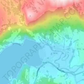
Name: Fitja topographic map, elevation, terrain.

Location: Fitja, Etne, Vestland, 5590, Norway (59.65461 5.91230 59.69461 5.95230)

Average elevation: 179 m

Minimum elevation: -3 m

Maximum elevation: 667 m

Gear up for your next adventure:

🧤Hiking Gloves - Warm and durable gloves for cold-weather walks
📐Altimeters & Barometers - Tools for measuring altitude and air pressure
🍳Camping Stoves - Compact stoves for outdoor cooking
🛰️Outdoor GPS Navigation - Navigation devices for remote and off-grid areas
🥼Base Layers - Thermal base layers for temperature regulation

As an Amazon Associate, this site earns from qualifying purchases at no extra cost to you.