
Make a donation
Gear up for your next adventure:
As an Amazon Associate, this site earns from qualifying purchases at no extra cost to you.
Großer Belchen topographic map
Click on the map to display elevation.
Make a donation
Gear up for your next adventure:
As an Amazon Associate, this site earns from qualifying purchases at no extra cost to you.
Großer Belchen
Der Große Belchen (französisch Grand Ballon) ist mit 1424 Metern Höhe der höchste Berg der Vogesen. Der Berg ist auch bekannt unter den Namen Sulzer oder Gebweiler Belchen (französisch Ballon de Guebwiller) nach den nächstliegenden Städten Soultz-Haut-Rhin (deutsch Sulz) und Guebwiller (deutsch Gebweiler) acht Kilometer östlich. Der Berg liegt im Regionalen Naturpark Ballons des Vosges.
Make a donation
Gear up for your next adventure:
As an Amazon Associate, this site earns from qualifying purchases at no extra cost to you.
About this map
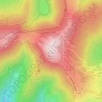
Name: Großer Belchen topographic map, elevation, terrain.
Average elevation: 1,139 m
Minimum elevation: 727 m
Maximum elevation: 1,419 m
Make a donation
Gear up for your next adventure:
As an Amazon Associate, this site earns from qualifying purchases at no extra cost to you.