Geolocate

Dorchester topographic map

Interactive map

Click on the map to display elevation.

About this map

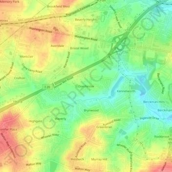
Name: Dorchester topographic map, elevation, terrain.

Location: Dorchester, Augusta, Richmond County, Georgia, 30909, United States (33.48208 -82.07206 33.52208 -82.03206)

Average elevation: 90 m

Minimum elevation: 54 m

Maximum elevation: 128 m

Other topographic maps

Click on a map to view its topography, its elevation and its terrain.

Augusta Canal

United States > Georgia > Richmond County > Augusta

Augusta Canal, Augusta, Richmond County, Georgia, United States

Average elevation: 80 m

Forest Acres

United States > Georgia > Richmond County > Augusta

Forest Acres, Augusta, Richmond County, Georgia, 30904, United States

Average elevation: 67 m

Fairvale

United States > Georgia > Richmond County > Augusta

Fairvale, Augusta, Richmond County, Georgia, 30906, United States

Average elevation: 56 m

Ellwood

United States > Georgia > Richmond County > Augusta

Ellwood, Augusta, Richmond County, Georgia, United States

Average elevation: 119 m

Berckman Villas

United States > Georgia > Richmond County > Augusta > Berckman Villas

Berckman Villas, Augusta, Richmond County, Georgia, 30904, United States

Average elevation: 87 m

Fort Gordon

United States > Georgia > Richmond County > Augusta > Fort Gordon

Fort Gordon, Augusta, Richmond County, Georgia, 30905, United States

Average elevation: 136 m