
Make a donation
Gear up for your next adventure:
As an Amazon Associate, this site earns from qualifying purchases at no extra cost to you.
Kazanlak topographic map
Click on the map to display elevation.
Make a donation
Gear up for your next adventure:
As an Amazon Associate, this site earns from qualifying purchases at no extra cost to you.
Kazanlak
The Bulgarian climate is temperate, with average temperatures from 0 °C (32 °F) to 1.5 °C (34.7 °F) in January, and 21 °C (70 °F) in July. The average altitude is 350 m (1,150 ft).
Make a donation
Gear up for your next adventure:
As an Amazon Associate, this site earns from qualifying purchases at no extra cost to you.
About this map
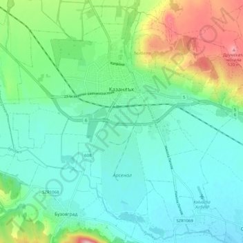
Name: Kazanlak topographic map, elevation, terrain.
Location: Kazanlak, Stara Zagora, Bulgaria (42.57459 25.34418 42.64402 25.44429)
Average elevation: 378 m
Minimum elevation: 324 m
Maximum elevation: 536 m
Make a donation
Gear up for your next adventure:
As an Amazon Associate, this site earns from qualifying purchases at no extra cost to you.
Other topographic maps
Click on a map to view its topography, its elevation and its terrain.
Make a donation
Gear up for your next adventure:
As an Amazon Associate, this site earns from qualifying purchases at no extra cost to you.