
Make a donation
Gear up for your next adventure:
As an Amazon Associate, this site earns from qualifying purchases at no extra cost to you.
As Safirah topographic map
Click on the map to display elevation.
Make a donation
Gear up for your next adventure:
As an Amazon Associate, this site earns from qualifying purchases at no extra cost to you.
As Safirah
As-Safira (Arabic: السَّفِيْرَة / ALA-LC: as-Safīrah; Aleppo dialect: Sfīre) is a Syrian city administratively belonging to the Aleppo Governorate. It is the administrative center of the as-Safira District. As Safīrah has an altitude of 348 meters (1,142 ft), and a population of 106,382 as of 2007, making it the 11th largest city per geographical entity in Syria.
Make a donation
Gear up for your next adventure:
As an Amazon Associate, this site earns from qualifying purchases at no extra cost to you.
About this map
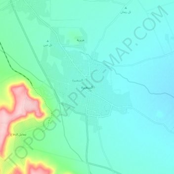
Name: As Safirah topographic map, elevation, terrain.
Average elevation: 353 m
Minimum elevation: 318 m
Maximum elevation: 516 m
Make a donation
Gear up for your next adventure:
As an Amazon Associate, this site earns from qualifying purchases at no extra cost to you.
Other topographic maps
Click on a map to view its topography, its elevation and its terrain.
Make a donation
Gear up for your next adventure:
As an Amazon Associate, this site earns from qualifying purchases at no extra cost to you.
Make a donation
Gear up for your next adventure:
As an Amazon Associate, this site earns from qualifying purchases at no extra cost to you.
Make a donation
Gear up for your next adventure:
As an Amazon Associate, this site earns from qualifying purchases at no extra cost to you.