
St. Ulrich bei Steyr topographic map
Interactive map
Click on the map to display elevation.
About this map
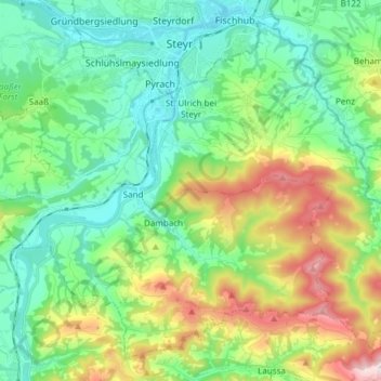
Name: St. Ulrich bei Steyr topographic map, elevation, terrain.
Average elevation: 464 m
Minimum elevation: 280 m
Maximum elevation: 906 m
Sankt Ulrich liegt direkt südlich der Stadt Steyr, am südlichen Westrand der Gemeinde. Die Rotte liegt etwa erhöht rechtsufrig der Enns. Der Ortskern mit der Ulrichskirche erhebt sich auf einem Riedel zwischen Rahofergraben und Freisingbach auf um die 380 m ü. A. Höhe. Südöstlich erhebt sich der Damberg (807 m ü. A.). An der Enns ist Sankt Ulrich schon gänzlich mit der Stadt Steyr verwachsen.
Other topographic maps
Click on a map to view its topography, its elevation and its terrain.
Bad Hall
Österreich > Oberösterreich > Bezirk Steyr-Land
Bad Hall, Bezirk Steyr-Land, Oberösterreich, 4540, Österreich
Average elevation: 389 m