
Thank you for supporting this site ❤️
Make a donation
Make a donation
Gear up for your next adventure:
As an Amazon Associate, this site earns from qualifying purchases at no extra cost to you.
Devils Lake topographic map
Click on the map to display elevation.
Thank you for supporting this site ❤️
Make a donation
Make a donation
Gear up for your next adventure:
As an Amazon Associate, this site earns from qualifying purchases at no extra cost to you.
About this map
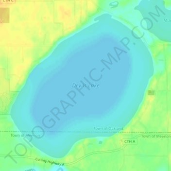
Name: Devils Lake topographic map, elevation, terrain.
Average elevation: 298 m
Minimum elevation: 288 m
Maximum elevation: 316 m
Thank you for supporting this site ❤️
Make a donation
Make a donation
Gear up for your next adventure:
As an Amazon Associate, this site earns from qualifying purchases at no extra cost to you.
Other topographic maps
Click on a map to view its topography, its elevation and its terrain.
Danbury
United States > Wisconsin > Burnett County > Town of Swiss
Danbury is located at 46.006N. The longitude is -92.371W. It is in the Central Standard Time Zone. The elevation is 938 feet (286 m) above sea level.
Average elevation: 287 m