Geolocate

Cisneros topographic map

Click on the map to display elevation.

Cisneros

Cisneros is a town and municipality in the Antioquia Department, Colombia. Part of the subregion of Northeastern Antioquia, it lies at an altitude of 1,050 m (3,440 ft) above sea level.

Wikipedia (CC-BY-SA 3.0)

About this map

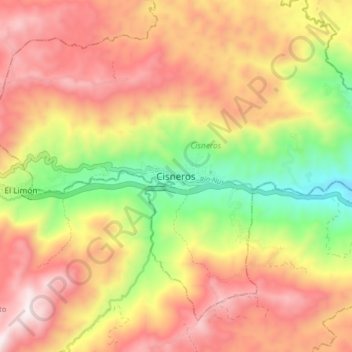
Name: Cisneros topographic map, elevation, terrain.

Location: Cisneros, Nordeste, Antioquia, RAP del Agua y la Montaña, Colombia (6.49824 -75.12713 6.57824 -75.04713)

Average elevation: 1,440 m

Minimum elevation: 880 m

Maximum elevation: 1,914 m

Gear up for your next adventure:

🧼Biodegradable Soap - Leave-no-trace hygiene for multi-day mountain treks
🧺Ultralight Dry Bags - Organize and waterproof your gear inside your rucksack
🧘Folding Sit Mats - Dry and warm seat for map-reading breaks on damp ground
🧤Waterproof Overmitts - Extreme weather protection for hikers and mountaineers
🔋Solar Chargers - Eco-friendly charging solutions for outdoor use

As an Amazon Associate, this site earns from qualifying purchases at no extra cost to you.