
Make a donation
Gear up for your next adventure:
As an Amazon Associate, this site earns from qualifying purchases at no extra cost to you.
Lyford topographic map
Click on the map to display elevation.
Make a donation
Gear up for your next adventure:
As an Amazon Associate, this site earns from qualifying purchases at no extra cost to you.
About this map
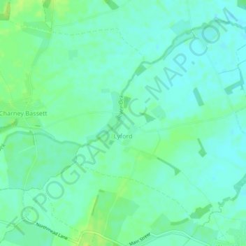
Name: Lyford topographic map, elevation, terrain.
Average elevation: 64 m
Minimum elevation: 58 m
Maximum elevation: 71 m
Oxfordshire trails, hiking, mountain biking, running and outdoor activities
Make a donation
Gear up for your next adventure:
As an Amazon Associate, this site earns from qualifying purchases at no extra cost to you.
Other topographic maps
Click on a map to view its topography, its elevation and its terrain.
Lamborough Hill
United Kingdom > England > Oxfordshire > Vale of White Horse > Wootton
Average elevation: 92 m
Boars Hill
United Kingdom > England > Oxfordshire > Vale of White Horse > Wootton
Average elevation: 106 m
Make a donation
Gear up for your next adventure:
As an Amazon Associate, this site earns from qualifying purchases at no extra cost to you.
The Spinney
United Kingdom > England > Oxfordshire > Vale of White Horse > Kingston Bagpuize
Average elevation: 77 m
Kingston Bagpuize
United Kingdom > England > Oxfordshire > Vale of White Horse
Average elevation: 76 m
Make a donation
Gear up for your next adventure:
As an Amazon Associate, this site earns from qualifying purchases at no extra cost to you.
Carswell Marsh
United Kingdom > England > Oxfordshire > Vale of White Horse > Buckland
Average elevation: 80 m
Sutton Pools
United Kingdom > England > Oxfordshire > Vale of White Horse > Abingdon > Sutton Courtenay
Average elevation: 54 m
Make a donation
Gear up for your next adventure:
As an Amazon Associate, this site earns from qualifying purchases at no extra cost to you.
Sutton Wick
United Kingdom > England > Oxfordshire > Vale of White Horse > Abingdon > Drayton
Average elevation: 57 m
Little Lews
United Kingdom > England > Oxfordshire > Vale of White Horse > Ardington
Average elevation: 183 m
Make a donation
Gear up for your next adventure:
As an Amazon Associate, this site earns from qualifying purchases at no extra cost to you.
White Horse Hill
United Kingdom > England > Oxfordshire > Vale of White Horse
Average elevation: 184 m
Farmoor
United Kingdom > England > Oxfordshire > Vale of White Horse > Farmoor
Average elevation: 81 m
Make a donation
Gear up for your next adventure:
As an Amazon Associate, this site earns from qualifying purchases at no extra cost to you.
Badger's Well
United Kingdom > England > Oxfordshire > Vale of White Horse > Appleton
Average elevation: 79 m