
Thank you for supporting this site ❤️
Make a donation
Make a donation
Gear up for your next adventure:
As an Amazon Associate, this site earns from qualifying purchases at no extra cost to you.
Palafolls topographic map
Click on the map to display elevation.
Thank you for supporting this site ❤️
Make a donation
Make a donation
Gear up for your next adventure:
As an Amazon Associate, this site earns from qualifying purchases at no extra cost to you.
About this map
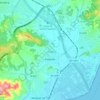
Name: Palafolls topographic map, elevation, terrain.
Location: Palafolls, Maresme, Barcelona, Catalonia, 08389, Spain (41.65181 2.69385 41.69288 2.76517)
Average elevation: 32 m
Minimum elevation: 0 m
Maximum elevation: 206 m
Thank you for supporting this site ❤️
Make a donation
Make a donation
Gear up for your next adventure:
As an Amazon Associate, this site earns from qualifying purchases at no extra cost to you.
Other topographic maps
Click on a map to view its topography, its elevation and its terrain.
Caldes d'Estrac
Spain > Catalonia > Maresme > Caldes d'Estrac > Caldes d'Estrac
Average elevation: 57 m