
Lac Achepabanca topographic map
Interactive map
Click on the map to display elevation.
About this map
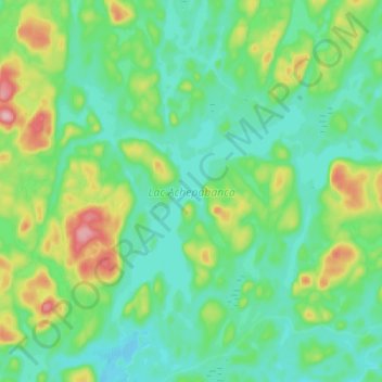
Name: Lac Achepabanca topographic map, elevation, terrain.
Average elevation: 423 m
Minimum elevation: 380 m
Maximum elevation: 546 m
Other topographic maps
Click on a map to view its topography, its elevation and its terrain.
Lac Guy
Canada > Québec > La Vallée-de-l'Or > Senneterre (ville)
Lac Guy, Senneterre (ville), La Vallée-de-l'Or, Abitibi-Témiscamingue, Québec, Canada
Average elevation: 443 m