
Biévène topographic map
Interactive map
Click on the map to display elevation.
About this map
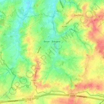
Name: Biévène topographic map, elevation, terrain.
Location: Biévène, Hal-Vilvorde, Brabant flamand, Flandre, 1547, Belgique (50.68897 3.88932 50.73304 3.97417)
Average elevation: 49 m
Minimum elevation: 21 m
Maximum elevation: 81 m
Other topographic maps
Click on a map to view its topography, its elevation and its terrain.
Rhode-Saint-Genèse
Belgique > Brabant flamand > Hal-Vilvorde
Rhode-Saint-Genèse, Hal-Vilvorde, Brabant flamand, Flandre, 1640, Belgique
Average elevation: 98 m
Malaise
Belgique > Brabant flamand > Hal-Vilvorde > Isque
Malaise, Isque, Hal-Vilvorde, Brabant flamand, 1331, Belgique
Average elevation: 87 m
Wesembeek
Belgique > Brabant flamand > Hal-Vilvorde > Wezembeek-Oppem
Wesembeek, Wezembeek-Oppem, Hal-Vilvorde, Brabant flamand, Flandre, 1970, Belgique
Average elevation: 65 m
Ophem
Belgique > Brabant flamand > Hal-Vilvorde > Wesembeek-Ophem > Ophem
Ophem, Wesembeek-Ophem, Hal-Vilvorde, Brabant flamand, Flandre, 1970, Belgique
Average elevation: 77 m