
Llandre topographic map
Interactive map
Click on the map to display elevation.
About this map
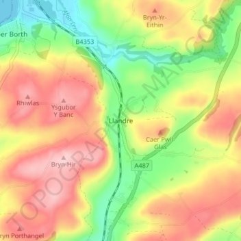
Name: Llandre topographic map, elevation, terrain.
Location: Llandre, Ceredigion, Wales, SY24 5DD, United Kingdom (52.44284 -4.04388 52.48284 -4.00388)
Average elevation: 91 m
Minimum elevation: 0 m
Maximum elevation: 175 m
Other topographic maps
Click on a map to view its topography, its elevation and its terrain.
Tai-gwynion
United Kingdom > Wales > Ceredigion > Llandre
Tai-gwynion, Geneu'r Glyn, Llandre, Ceredigion, Wales, SY24 5AG, United Kingdom
Average elevation: 93 m