
Ombersley topographic map
Interactive map
Click on the map to display elevation.
About this map
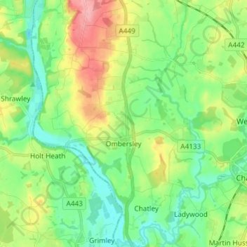
Name: Ombersley topographic map, elevation, terrain.
Location: Ombersley, Wychavon, Worcestershire, England, United Kingdom (52.23806 -2.27605 52.31205 -2.19134)
Average elevation: 45 m
Minimum elevation: 11 m
Maximum elevation: 111 m
Worcestershire trails, hiking, mountain biking, running and outdoor activities
Other topographic maps
Click on a map to view its topography, its elevation and its terrain.
Badsey Lane Nature Reserve
United Kingdom > England > Worcestershire > Wychavon > Evesham
Average elevation: 37 m
Atch Lench
United Kingdom > England > Worcestershire > Wychavon > Church Lench
Average elevation: 80 m