
Berric topographic map
Interactive map
Click on the map to display elevation.
About this map
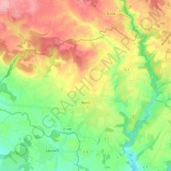
Name: Berric topographic map, elevation, terrain.
Average elevation: 75 m
Minimum elevation: 17 m
Maximum elevation: 138 m
Other topographic maps
Click on a map to view its topography, its elevation and its terrain.
Île aux Chevaux
Francia > Bretagna > Morbihan > Île-d'Houat
Île aux Chevaux, Île-d'Houat, Lorient, Morbihan, Bretagna, Francia metropolitana, 56170, Francia
Average elevation: 0 m