
Pumpherston topographic map
Interactive map
Click on the map to display elevation.
About this map
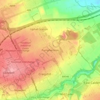
Name: Pumpherston topographic map, elevation, terrain.
Location: Pumpherston, West Lothian, Scotland, EH53 0PQ, United Kingdom (55.88799 -3.51408 55.92799 -3.47408)
Average elevation: 119 m
Minimum elevation: 62 m
Maximum elevation: 161 m
Other topographic maps
Click on a map to view its topography, its elevation and its terrain.
Armadale
United Kingdom > Scotland > West Lothian
Armadale, West Lothian, Scotland, EH48 3QB, United Kingdom
Average elevation: 166 m
Addiewell
United Kingdom > Scotland > West Lothian
Addiewell, West Lothian, Scotland, EH55 8HN, United Kingdom
Average elevation: 196 m