
Engels topographic map
Interactive map
Click on the map to display elevation.
About this map
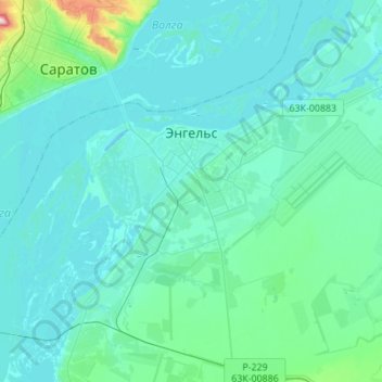
Name: Engels topographic map, elevation, terrain.
Average elevation: 31 m
Minimum elevation: 7 m
Maximum elevation: 244 m
Other topographic maps
Click on a map to view its topography, its elevation and its terrain.
озеро Вербовое
Russia > Saratov Oblast > Engelssky District > Engels
озеро Вербовое, Engels, городское поселение Энгельс, Engelssky District, Saratov Oblast, Volga Federal District, 413100, Russia
Average elevation: 20 m