Geolocate

Tokha topographic map

Interactive map

Click on the map to display elevation.

About this map

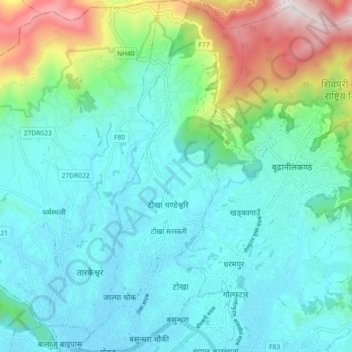
Name: Tokha topographic map, elevation, terrain.

Location: Tokha, Kathmandu, Bagmati Pradesh, Nepal (27.73491 85.30718 27.81536 85.34952)

Average elevation: 1,547 m

Minimum elevation: 1,301 m

Maximum elevation: 2,438 m

Other topographic maps

Click on a map to view its topography, its elevation and its terrain.

Namgyal

Nepal > Kathmandu

Namgyal, Gokarneshwar Municipality, Kathmandu, 46603, Nepal

Average elevation: 1,366 m

Kathmandu

Nepal > Kathmandu

Kathmandu, Bagmati Pradesh, Nepal

Average elevation: 1,335 m

Kirtipur

Nepal > Kathmandu

Kirtipur, Kathmandu, Bagmati Pradesh, 44618, Nepal

Average elevation: 1,380 m

Kirtipur

Nepal > Kathmandu

Kirtipur, Kathmandu, Bagmati Pradesh, 44618, Nepal

Average elevation: 1,414 m