
Make a donation
Gear up for your next adventure:
As an Amazon Associate, this site earns from qualifying purchases at no extra cost to you.
Hell-Bourg topographic map
Click on the map to display elevation.
Make a donation
Gear up for your next adventure:
As an Amazon Associate, this site earns from qualifying purchases at no extra cost to you.
Hell-Bourg
L'établissement thermal créé le 13 juillet 1852 connut une période d'apogée en 1875, malgré un débit horaire relativement limité (environ 1,1 litre par seconde) et une minéralisation faible. Les classes aisées du littoral de l'île, attirées par les thermes d'Hell-Bourg, venaient également profiter de la fraîcheur du cirque de Salazie dans un mouvement appelé changement d'air. Peu à peu, une vie mondaine s'organise : on assiste successivement à la construction et la location de villas (résidences secondaires), et à l’ouverture d'un casino. Ce qui fait d'Hell-Bourg une station d'altitude à la mode qui prend une allure urbaine avec 150 cases créoles d'un style architectural raffiné.
Make a donation
Gear up for your next adventure:
As an Amazon Associate, this site earns from qualifying purchases at no extra cost to you.
About this map
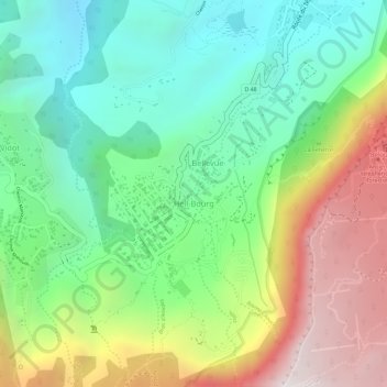
Name: Hell-Bourg topographic map, elevation, terrain.
Location: Hell-Bourg, Salazie, Saint-Benoît, La Réunion, 97433, France (-21.07116 55.51580 -21.05587 55.52930)
Average elevation: 1,039 m
Minimum elevation: 614 m
Maximum elevation: 1,686 m
Make a donation
Gear up for your next adventure:
As an Amazon Associate, this site earns from qualifying purchases at no extra cost to you.