
Gubbi topographic map
Interactive map
Click on the map to display elevation.
About this map
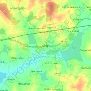
Name: Gubbi topographic map, elevation, terrain.
Location: Gubbi, Gubbi taluk, Tumkur district, Karnataka, 572216, India (13.26957 76.90007 13.34957 76.98007)
Average elevation: 784 m
Minimum elevation: 764 m
Maximum elevation: 809 m
Other topographic maps
Click on a map to view its topography, its elevation and its terrain.
Mookanahalli Patna Kere
India > Karnataka > Gubbi taluk > Mukanahalli Pattana
Mookanahalli Patna Kere, Mukanahalli Pattana, Gubbi taluk, Tumkur district, Karnataka, India
Average elevation: 783 m