
Jabal Saraj topographic map
Interactive map
Click on the map to display elevation.
About this map
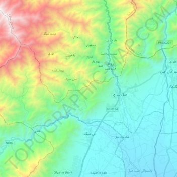
Name: Jabal Saraj topographic map, elevation, terrain.
Location: Jabal Saraj, Parwan Province, Afghanistan (35.08176 69.07359 35.17218 69.29303)
Average elevation: 2,082 m
Minimum elevation: 1,471 m
Maximum elevation: 3,758 m
Jabal Saraj town has a Mediterranean climate (Köppen climate classification Csa) with hot, dry summers and cold, wet winters. Snow is not unusual in winter. Nearby areas may have a cold semi-arid climate (Köppen climate classification BSk) or a humid continental climate (Köppen climate classification Dsa/Dsb) depending on altitude and topography.