
Guadalupe Peak topographic map
Interactive map
Click on the map to display elevation.
About this map
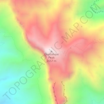
Name: Guadalupe Peak topographic map, elevation, terrain.
Average elevation: 2,151 m
Minimum elevation: 1,625 m
Maximum elevation: 2,651 m
Guadalupe Peak, also known as Signal Peak, is the highest natural point in Texas, with an elevation of 8,751 feet (2,667 m) above sea level. It is located in Guadalupe Mountains National Park, and is part of the Guadalupe Mountains range in southeastern New Mexico and West Texas. The mountain is about 90 miles (140 km) east of El Paso and about 50 miles (80 km) southwest of Carlsbad, New Mexico. The peak rises more than 3,000 feet (910 m) above the arid floor of the Chihuahuan Desert.
Other topographic maps
Click on a map to view its topography, its elevation and its terrain.
El Capitan
United States > Texas > Culberson County
El Capitan, Culberson County, Texas, 79847, United States
Average elevation: 1,916 m