
10e Thor topographic map
Interactive map
Click on the map to display elevation.
About this map
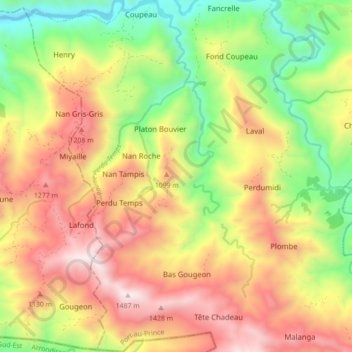
Name: 10e Thor topographic map, elevation, terrain.
Location: 10e Thor, Kafou, Port-au-Prince, West, Haiti (18.39648 -72.45330 18.47940 -72.41897)
Average elevation: 826 m
Minimum elevation: 184 m
Maximum elevation: 1,493 m
Other topographic maps
Click on a map to view its topography, its elevation and its terrain.
11e Rivière Froide
Haiti > West > Port-au-Prince
11e Rivière Froide, Kafou, Port-au-Prince, West, Haiti
Average elevation: 621 m
6e Turgeau
Haiti > West > Port-au-Prince
6e Turgeau, Pòtoprens, Port-au-Prince, West, Haiti
Average elevation: 195 m
7e Morne l'Hopital
Haiti > West > Port-au-Prince
7e Morne l'Hopital, Pòtoprens, Port-au-Prince, West, 6116, Haiti
Average elevation: 416 m
7e Bellevue Chardonnières
Haiti > West > Port-au-Prince
7e Bellevue Chardonnières, Petyonvil, Port-au-Prince, West, Haiti
Average elevation: 403 m
Port-au-Prince
Haiti > West > Port-au-Prince
Port-au-Prince, West, BP98, Haiti
Average elevation: 376 m