
Knott County topographic map
Interactive map
Click on the map to display elevation.
About this map
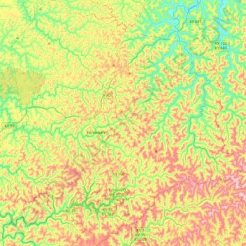
Name: Knott County topographic map, elevation, terrain.
Location: Knott County, Kentucky, United States (37.17245 -83.13484 37.52606 -82.71095)
Average elevation: 412 m
Minimum elevation: 198 m
Maximum elevation: 717 m
Other topographic maps
Click on a map to view its topography, its elevation and its terrain.
Hindman
United States > Kentucky > Knott County
Hindman, Knott County, Kentucky, United States
Average elevation: 388 m
Dry Creek
United States > Kentucky > Knott County
Dry Creek, Knott County, Kentucky, 41606, United States
Average elevation: 425 m