
Ringwood topographic map
Interactive map
Click on the map to display elevation.
About this map
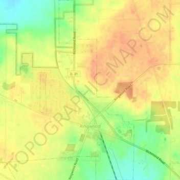
Name: Ringwood topographic map, elevation, terrain.
Location: Ringwood, McHenry County, Illinois, United States (42.38216 -88.32243 42.41561 -88.28599)
Average elevation: 263 m
Minimum elevation: 237 m
Maximum elevation: 278 m
Other topographic maps
Click on a map to view its topography, its elevation and its terrain.
6316
United States > Illinois > McHenry County > Ringwood
6316, Harts Road, Ringwood, McHenry County, Illinois, 60072, United States
Average elevation: 244 m