
Kitkatla topographic map
Click on the map to display elevation.
About this map
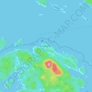
Name: Kitkatla topographic map, elevation, terrain.
Average elevation: 14 m
Minimum elevation: -5 m
Maximum elevation: 171 m
Other topographic maps
Click on a map to view its topography, its elevation and its terrain.
McCauley Island
Canada > British Columbia > North Coast Regional District > Area C (South Skeena)
Average elevation: 91 m
Anger Island
Canada > British Columbia > North Coast Regional District > Area C (South Skeena)
Average elevation: 48 m
Philip Island
Canada > British Columbia > North Coast Regional District > Area C (South Skeena)
Average elevation: 7 m