
Thank you for supporting this site ❤️
Make a donation
Make a donation
Gear up for your next adventure:
As an Amazon Associate, this site earns from qualifying purchases at no extra cost to you.
Tibirita topographic map
Click on the map to display elevation.
Thank you for supporting this site ❤️
Make a donation
Make a donation
Gear up for your next adventure:
As an Amazon Associate, this site earns from qualifying purchases at no extra cost to you.
About this map
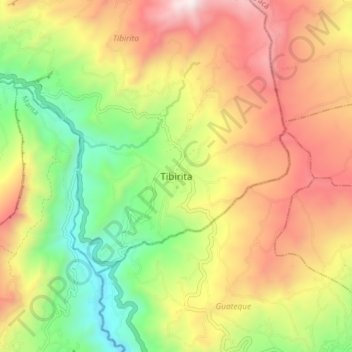
Name: Tibirita topographic map, elevation, terrain.
Location: Tibirita, Almeidas, RAP (Especial) Central, Colombia (5.01210 -73.54499 5.09210 -73.46499)
Average elevation: 2,069 m
Minimum elevation: 1,431 m
Maximum elevation: 2,774 m
Thank you for supporting this site ❤️
Make a donation
Make a donation
Gear up for your next adventure:
As an Amazon Associate, this site earns from qualifying purchases at no extra cost to you.