
Kettenham topographic map
Interactive map
Click on the map to display elevation.
About this map
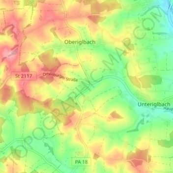
Name: Kettenham topographic map, elevation, terrain.
Average elevation: 389 m
Minimum elevation: 331 m
Maximum elevation: 450 m
Other topographic maps
Click on a map to view its topography, its elevation and its terrain.
Ledering
Deutschland > Bayern > Landkreis Passau > Beutelsbach
Ledering, Beutelsbach, Aidenbach, Landkreis Passau, Bayern, 94542, Deutschland
Average elevation: 390 m